 Coopracambra National Park is in the Eastern corner of Victoria, where the Monaro Highway crosses the border into NSW. Like the Parks page says, it's remote and largely undisturbed. We spent five days off track there between Boxing Day and New Years, including two days walking down the Genoa River, and enjoyed ourselves thoroughly. The walk was made up based on topo maps alone; we were well rewarded for staying away from the few tracks that exist in the park. We didn't encounter anyone until day three, when we passed nearby the Yambulla Peak track.
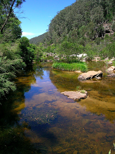
Progress along rivers and creeks is slow, we averaged about 1km/hr, but that's really where much of the best scenery (and all the swimming) is to be had. Make sure your packliner really is waterproof, and be prepared to dog-paddle with the pack floating loosely on your shoulders in a couple of places. Mostly the water was mid-thigh or lower. Forget walking along the banks - you're either in the water, rock-hopping, or dodging scrub on a spur.
When away from the water it is definitely worth staying right on top of the spur-lines; even there it gets quite slow and scrubby in places, but we always found it passable. Gaiters and zip-off longs are the go, so that you have the option for knee protection - it's scratchy stuff.
We didn't boil or treat any of the water on the walk, and I was fine - but the others experienced some gastro in the 48hrs since we left. It's hard to know which part of the park the bad water came from, as I drank what they drank, and all the catchments certainly looked good on the map. But the badness is likely at or near Beehive Falls, as that's where we finished.
This is certainly somewhere that you'll want to be self-sufficient. Don't expect facilities or mobile phone coverage. Do expect to see some snakes - gaiter up. You'll also attract plenty of interest from biting March flies and mozzies, we were grateful for the loan of a mozzie net to hang under our tarp.
Here are the photos. There would be more if I had a waterproof camera, so you'll just have to believe me about the best bits of scenery. There's a fantastic variety of rocks poking out of the river bed, and some imposing cliffs rising above the waters edge. I suggest visiting the spots on the river indicated on the map as having steep sides - and remember, those are 20m contour intervals.
I look for some variety in a walk, and the contrast between walking the ridgelines and the watercourses was a real highlight here. We were lucky to have significant rain in the week before we went, but I get the impression this is a rewarding place to visit at any time of year.
No comments:
Post a Comment